Aerial map mashing

Newtown Creek

Thanks to Jeff Warren (also here) of GrassRootsMapping and  Public Laboratory, I now know — and am highly turned on by — the possibilities of mapping in the wild. That is, mapping by the 99.xxx+% of us who are not in the mapping business, and are in the best multiple positions to map the world(s) in four running dimensions.

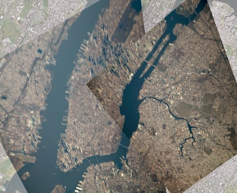
Check Jeff’s latest post at MapKnitter for what extra good can come from the series of shots I took of New York from altitude recently, and blogged about here. Pretty damn cool.

The thought now of what can be done with my many thousands of aerial photos is both exhiliarating and daunting. Fortunately, the work won’t be just mine — or any one person’s. And that’s what’s most cool about it.


3 responses to “Aerial map mashing”

  1. It was a fun map to make. I’m so glad all your images are CC-BY — I have very high hopes for finding and rectifying some of your mountaintop mining photos and seeing if some of the Mountain Justice movement could use them. I think you mentioned some already had. See for example some stuff we’ve done with balloons:

    http://publiclaboratory.org/map/black-mountain-virginia/2010-05-30
    http://publiclaboratory.org/map/marsh-fork-elementary-coal-river-west-virginia/2010-06-01

    I also hope your great photos inspire others to do this kind of mapmaking — for anyone who flies, it’s a great way to contribute to open source cartography and even monitoring of pollution sites.

  2. is this actual recent photos ? is that the freedom tower i see in lower manhattan?

  3. avi, the photos were taken on March 14 of this year. Here’s a full-size view of one shot. The freedom tower, now at more than 90 floors, is quite visible, as are hundreds of other landmarks.

Leave a Reply

Your email address will not be published. Required fields are marked *