Making sense of what happened to Montecito

Montecito is now a quarry with houses in it:

So far twenty dead have been removed. It will take much more time to remove twenty thousand dump truck loads of what geologists call “debris,” just to get down to where civic infrastructure (roads, water, electric, gas) can be fixed. It’s a huge thing.

The big questions:

  1. Did we know a catastrophe this huge was going to happen? (And if so, which among us were the “we” who knew?)
  2. Was there any way to prevent it?

Geologists had their expectations, expressed as degrees of likelihood and detailed on this map by the United States Geological Survey:

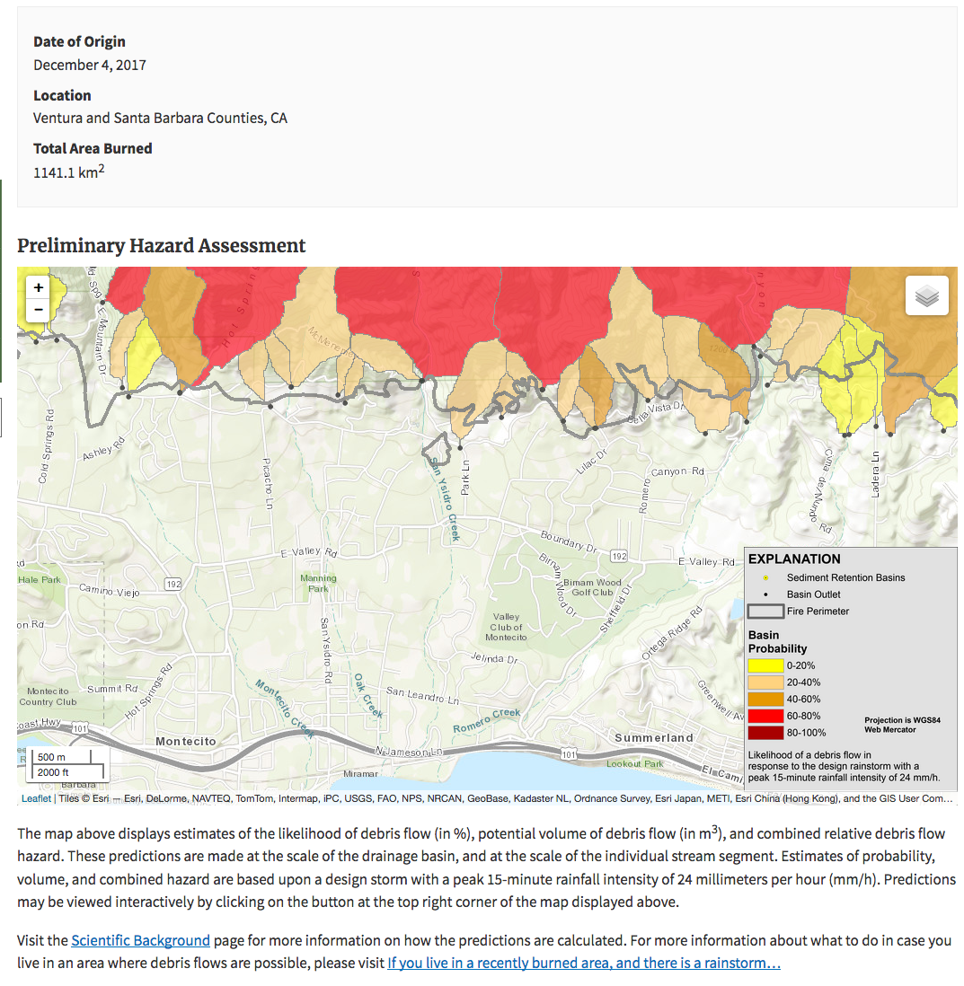
That was dated more than a month before huge rains revised to blood-red the colors in the mountains above town. Worries of County Supervisors and other officials were expressed in The Independent on January 3rd and 5th. Edhat also issued warnings on January 5th and 6th.

Edhat’s first report began, “Yesterday, the National Weather Service issued a weather briefing of a potential significant winter storm for Santa Barbara County on January 9-10. With the burn scar created by the Thomas Fire, the threat of flash floods and debris/mud flows is now 10 times greater than before the fire.”

But among those at risk, who knew what a “debris/mud flow” was—especially when nobody had ever seen one of those anywhere around here, even after prior fires?

The first Independent story (on January 3rd) reported, “County water expert Tom Fayram said county workers began clearing the debris basins at San Ysidro and Gobernador canyons ‘as soon as the fire department would let us in.’ It is worth noting, Lewin said, that the Coast Village Road area flooded following the 1971 Romero Fire and the 1964 Coyote Fire. While touring the impact areas in recent days, (Office of Emergency Management Director Robert) Lewin said problems have already occurred. ‘We’re starting to see gravity rock fall, he said. ‘One rock could close a road.’”

The best report I’ve seen about what geologists knew, and expected, is The Independent‘s After the Mudslides, What Does the Next Rain Hold for Montecito?, published four days after the disaster. In that report, Kevin Cooper of the U.S. Forest Service said, “no one alive has probably ever seen one before.” [January 18 update: Nick Welch in The Independent reports, “Last week’s debris flow was hardly Santa Barbara’s first. Jim Stubchaer, then an engineer with County Flood Control, remembers the avalanche of mud that took 250 homes back in November 1964 when heavy rains followed quickly on the heels of the Coyote Fire. He was there in 1969 and 1971 when it happened again.” Here is a long 2009 report on the Coyote Fire in The Independent by Ray Ford, now with Noozhawk. No mention of the homes lost in there. Perhaps Ray can weigh in.]

My point is that debris flows over Montecito ae a sure bet in geologic time, but not in the human one. In the whole history of Montecito and Santa Barbara (of which Montecito is an unincorporated part), there are no recorded debris flows that started on mountain slopes and spread all the way to the sea. But on January 9th we had several debris flows on that scale, originating simultaneously in the canyons feeding Montecito, San Ysidro and Romero Creeks. Those creeks are dry most of the time, and beautiful areas in which to build homes: so beautiful, in fact, that Montecito is the other Beverly Hills. (That’s why all these famous people have called it home.)

One well-studied prehistoric debris flow in Santa Barbara emptied a natural lake that is now Skofield Park,dumping long-gone mud and lots of rocks in Rattlesnake Canyon, leaving its clearest evidence in a charming tree-shaded boulder field next to Mission Creek called Rocky Nook Park.

What geologists at UCSB learned from that flow is detailed in a 2001 report titled UCSB Scientists Study Ancient Debris Flows. It begins, “The next ‘big one’ in Santa Barbara may not be an earthquake but a boulder-carrying flood.” It also says that flood would “most likely occur every few thousand years.”

And we got one in Montecito last Tuesday.

I’ve read somewhere that studies of charcoal from campfires buried in Rocky Nook Park date that debris flow at around 500 years ago. This is a good example of how the geologic present fails to include present human memory. Still, you can get an idea of how big this flow was. Stand in Rattlesnake Canyon downstream from Skofield Park and look at the steep rocky slopes below houses on the south side of the canyon. It isn’t hard to imagine the violence that tore out the smooth hillside that had been there before.

To help a bit more with that exercise, here is a Google Streetview of Scofield Park, looking down at Santa Barbara through Rattlesnake Canyon:

I added the red line to show the approximate height of the natural dam that broke and released that debris flow.

I’ve also learned that the loaf-shaped Riviera landform in Santa Barbara is not a hunk of solid rock, but rather what remains of a giant landslide that slid off the south face of the Santa Ynez Mountains and became free-standing after creeks eroded out the valley behind. I’ve also read that Mission Creek flows westward around the Riviera and behind the Mission because the Riviera itself is also sliding the same direction on its own tectonic sled.

We only see these sleds moving, however, when geologic and human time converge. That happened last Tuesday when rains Kevin Cooper calls “biblical” hit in the darkest hours, saturating the mountain face creek beds that were burned by the Thomas Fire just last month. As a result, debris flows gooped down the canyons and stream valleys below, across Montecito to the sea, depositing lots of geology on top of what was already there.

So in retrospect, those slopes in various colors in the top map above should have been dark red instead. But, to be fair, much of what geology knows is learned the hard way.

Our home, one zip code west of Montecito, is fine. But we can’t count how many people we know who are affected directly. One friend barely escaped. Some victims were friends of friends. Some of the stories are beyond awful.

We all process tragedies like this in the ways we know best, and mine is by reporting on stuff, hopefully in ways others are not, or at least not yet. So I’ll start with this map showing damaged and destroyed buildings along the creeks:

At this writing the map is 70% complete. [January 17 update: 95%.] I’ve clicked on all the red dots (which mark destroyed buildings, most of which are homes), and I’ve copied and pasted the addresses that pop up into the following outline, adding a few links.

Going downstream along Cold Spring Creek, Hot Springs Creek and Montecito Creek (which the others feed), gone are—
  1. 817 Ashley Road
  2. 817 Ashley Road (out building)
  3. 797 Ashley Road
  4. 780 Ashley Road. Amazing architectural treasure that last sold for $12.9 million in ’13.
  5. 809 Ashley Road
  6. 809 Ashley Road (there are two at one address)
  7. 747 Indian Lane
  8. 631 Parra Grande Lane. That’s the mansion where the final scene in Scarface was shot.
  9. 590 Meadowood Lane
  10. 830 Rockbridge Road
  11. 800 Rockbridge Road
  12. 790 Rockbridge Road
  13. 787 Riven Rock Road B
  14. 1261 East Valley Road
  15. 1240 East Valley Road A (mansion)
  16. 1240 East Valley Road B (out building)
  17. 1254 East Valley Drive
  18. 1255 East Valley Road
  19. 1247 East Valley Road A
  20. 1247 East Valley Road B (attached)
  21. 1231 East Valley Road A
  22. 1231 East Valley Road B (detached)
  23. 1231 East Valley Road C (detached)
  24. 1221 East Valley Road A
  25. 1221 East Valley Road B
  26. 369 Hot Springs Road
  27. 341 Hot Springs Road A
  28. 341 Hot Springs Road B
  29. 341 Hot Springs Road C
  30. 355 Hot Springs Road
  31. 335 Hot Springs Road A
  32. 335 Hot Springs Road B
  33. 333 Hot Springs Road (Not marked in final map)
  34. 341 Hot Springs Road A
  35. 341 Hot Springs Road B
  36. 341 Hot Springs Road C
  37. 340 Hot Springs Road
  38. 319 Hot Springs Road
  39. 325 Olive Mill Road
  40. 285 Olive Mill Road
  41. 275 Olive Mill Road
  42. 325 Olive Mill Road
  43. 220 Olive Mill Road
  44. 200 Olive Mill Road
  45. 275 Olive Mill Road
  46. 180 Olive Mill Road
  47. 170 Olive Mill Road
  48. 144 Olive Mill Road
  49. 137 Olive Mill Road
  50. 139 Olive Mill Road
  51. 127 Olive Mill Road
  52. 196 Santa Elena Lane
  53. 192 Santa Elena Lane
  54. 179 Santa Isabel Lane
  55. 175 Santa Elena Lane
  56. 142 Santo Tomas Lane
  57. 82 Olive Mill Road
  58. 1308 Danielson Road
  59. 81 Depot Road
  60. 75 Depot Road
Along Oak Creek—
  1. 601 San Ysidro Road
  2. 560 San Ysidro Road B
Along San Ysidro Creek—
  1. 953 West Park Lane
  2. 941 West Park Lane
  3. 931 West park Lane
  4. 925 West park Lane
  5. 903 West park Lane
  6. 893 West park Lane
  7. 805 W Park Lane
  8. 881 West park Lane
  9. 881 West park Lane (separate building, same address)
  10. 1689 Mountain Drive
  11. 900 San Ysidro Lane C (all the Lane addresses appear to be in San Ysidro Ranch)
  12. 900 San Ysidro Lane Cottage B
  13. 900 San Ysidro Lane Cottage A
  14. 900 San Ysidro Lane Cottage D
  15. 900 San Ysidro Lane E
  16. 900 San Ysidro Lane F
  17. 900 San Ysidro Lane G
  18. 900 San Ysidro Lane H
  19. 900 San Ysidro Lane I
  20. 900 San Ysidro Lane J
  21. 900 San Ysidro Lane K
  22. 900 San Ysidro Lane L
  23. 900 San Ysidro Lane M
  24. 900 San Ysidro Lane N
  25. 900 San Ysidro Lane O
  26. 900 San Ysidro Lane R
  27. 900 San Ysidro Lane S
  28. 900 San Ysidro Lane T
  29. 888 San Ysidro Lane A
  30. 888 San Ysidro Lane B
  31. 888 San Ysidro Lane C
  32. 888 San Ysidro Lane D
  33. 888 San Ysidro Lane E
  34. 888 San Ysidro Lane F
  35. 805 West Park Lane B
  36. 799 East Mountain Drive
  37. 1801 East Mountain Lane
  38. 1807 East Mountain Drive
  39. 771 Via Manana Road
  40. 899 El Bosque Road
  41. 771 Via Manana Road
  42. 898 El Bosque Road
  43. 800 El Bosque Road A (Casa de Maria)
  44. 800 El Bosque Road B (Casa de Maria)
  45. 800 El Bosque Road C (Casa de Maria)
  46. 559 El Bosque Road (This is between Oak Creek and San Ysidro Creek)
  47. 680 Randall Road
  48. 670 Randall Road
  49. 660 Randall Road
  50. 650 Randall Road
  51. 640 Randall Road
  52. 630 Randall Road
  53. 619 Randall Road
  54. 1685 East Valley Road A
  55. 1685 East Valley Road B
  56. 1685 East Valley Road C
  57. 1696 East Valley Road
  58. 1760 Valley Road A
  59. 1725 Valley Road A
  60. 1705 Glenn Oaks Drive A
  61. 1705 Glen Oaks Drive B
  62. 1710 Glen Oaks Drive A
  63. 1790 Glen Oaks Drive A
  64. 1701 Glen Oaks Drive A
  65. 1705 Glen Oaks Drive A
  66. 1705 East Valley Road A
  67. 1705 East Valley Road B
  68. 1705 East Valley Road C
  69. 1780 Glen Oaks Drive N/A
  70. 1780 Glen Oaks Drive (one on top of the other)
  71. 1774 Glen Oaks Drive
  72. 1707 East Valley Road A
  73. 1685 East Valley Road C
  74. 1709 East Valley Road
  75. 1709 East Valley Road B
  76. 1775 Glen Oaks Drive A
  77. 1775 Glen Oaks Drive B
  78. 1779 Glen Oaks Drive A
  79. 1779 Glen Oaks Drive B
  80. 1779 Glen Oaks Drive C
  81. 1781 Glen Oaks Drive A
  82. 1711 East Valley Road (This and what follow are adjacent to Oprah)
  83. 1715 East Valley Road A
  84. 1715 East Valley Road B
  85. 1719 East Valley Road
  86. 1721 East Valley Road A (This might survive. See Dan Seibert’s comment below)
  87. 1721 East Valley Road B (This might survive. See Dan Seibert’s comment below)
  88. 1721 East Valley Road C (This might survive. See Dan Seibert’s comment below)
  89. 1694 San Leandro Lane A
  90. 1694 San Leandro Lane D
  91. 1690 San Leandro Lane C
  92. 1690 San Leandro Lane A
  93. 1694 San Leandro Lane B
  94. 1696 San Leandro Lane
  95. 1710 San Leandro Lane A
  96. 1710 San Leandro Lane B
  97. 190 Tiburon Bay Lane
  98. 193 Tiburon Bay Lane A
  99. 193 Tiburon Bay Lane B
  100. 193 Tiburon Bay Lane C
  101. 197 Tiburon Bay Lane A
Along Buena Vista Creek—
  1. 923 Buena Vista Avenue
  2. 1984 Tollis Avenue A
  3. 1984 Tollis Avenue B
  4. 1984 Tollis Avenue C
  5. 670 Lilac Drive
  6. 658 Lilac Drive
  7. 2075 Alisos Drive (marked earlier, but I don’t see it in the final map)
  8. 627 Oak Grove Lane
Along Romero Creek—
  1. 1000 Romero Canyon Road
  2. 1050 Romero Canyon Road
  3. 860 Romero Canyon Road
  4. 768 Winding Creek Lane
  5. 745 Winding Creek Lane
  6. 744 Winding Creek Lane
  7. 2281 Featherhill Avenue B

Below Toro Canyon—

  1. 876 Toro Canyon Road
  2. 572 Toro Canyon Park Road

Along Arroyo Paredon, between Summerland and Carpinteria, not far east of the Toro Canyon—

  1. 2000 Cravens Lane

Ten flanking Highway 101 by the ocean are marked as damaged, including four on Padero Lane.

When I add those up, I get 142 163* 178† among the destroyed alone.

[* This is on January 17, when the map says it is 95% complete. All the additions appear to be along San Ysidro Creek, especially on San Ysidro Lane, which I believe is mostly in San Ysidro Ranch. Apparently nearly the whole place has been destroyed. Adjectives such as “lovely” fail to describe what it was.]

[† This is on January 18, when the map is complete. I’ll need to go over it again, because there are subtractions as well as additions. Additional note: on March 22, the resident at 809 Ashley Road asked me to make sure that address was also added. There are two homes at that address, both gone.]

Now let’s go back and look more closely at this again from the geological perspective.

What we see is a town revised by nature in full disregard for what was there before—and in full obedience to the pattern of alluvial deposition on the flanks of all fresh mountains that erode down almost as fast as they go up.

This same pattern accounts for much of California, including all of the South Coast and the Los Angeles basin.

To see what I mean, hover your mind above Atlanta and look north at the southern Appalachians. Then dial history back five million years. What you see won’t look much different. Do the same above Los Angeles or San Francisco and nothing will be the same, or even close. Or even there at all.

Five million years is about 1/1000th of Earth’s history. If that history were compressed to a day, California showed up in less than the last forty seconds. In that short time California has formed and re-formed constantly, and is among the most provisional landscapes in the world. All of it is coming up, sliding down, spreading out and rearranging itself, and will continue doing so through all the future that’s worth bothering to foresee. Debris flows are among nature’s most casual methods for revising landscapes. (By the way, I am writing this in a San Marino house that sits atop the Raymond Fault scarp, which on the surface takes the form of a forty-foot hill. The stack of rock strata under the bottom of that hill is displaced 17,000 feet from the identical suite under the base at the top. Many earthquakes produced that displacement, while erosion has buffed 16,960 feet of rock and soil off the top.)

So we might start to look at the Santa Ynez Mountains behind Santa Barbara and Montecito not as a stable land form but rather as a volcano of mud and rock that’s sure to go off every few dozen or hundreds of years—and will possibly deliver a repeat performance if we get more heavy rains and there is plenty of debris left to flow out of mountain areas adjacent to those that flowed on January 9th. If there’s a lot of it, why even bother saving Montecito?

Here’s why:

One enters the Engineering building at the University of Wyoming under that stone plaque, which celebrates what may be our species’ greatest achievement and conceit: controlling nature. (It’s also why geology is starting to call our present epoch the anthropocene.)

This also forecasts exactly what we will do for Montecito. In the long run we’ll lose to nature. But meanwhile we strive on.

In our new strivings, it will help to look toward other places in California that are more experienced with debris flows, because they happen almost constantly there. The largest of these by far is Los Angeles, which has placed catch basins at the mouths of all the large canyons coming out of the San Gabriel Mountains. Most of these dwarf the ones above Montecito. All resemble empty reservoirs. Some are actually quarries for rocks and gravel that roll in constantly from the eroding creek beds above. None are pretty.

To understand the challenge involved, it helps to read John McPhee’s classic book The Control of Nature, which takes its title from the inscription above. Fortunately, you can start right now by reading the first essay in a pair that became the relevant chapter of that book. It’s free on the Web and called Los Angeles Against the Mountains I. Here’s an excerpt:

Debris flows amass in stream valleys and more or less resemble fresh concrete. They consist of water mixed with a good deal of solid material, most of which is above sand size. Some of it is Chevrolet size. Boulders bigger than cars ride long distances in debris flows. Boulders grouped like fish eggs pour downhill in debris flows. The dark material coming toward the Genofiles was not only full of boulders; it was so full of automobiles it was like bread dough mixed with raisins.

The Genofiles were a family that barely survived a debris flow on a slope of Verdugo Mountain, overlooking Los Angeles from Glendale. Here’s another story, about another site not far away:

The snout of the debris flow was twenty feet high, tapering behind. Debris flows sometimes ooze along, and sometimes move as fast as the fastest river rapids. The huge dark snout was moving nearly five hundred feet a minute and the rest of the flow behind was coming twice as fast, making roll waves as it piled forward against itself—this great slug, as geologists would describe it, this discrete slug, this heaving violence of wet cement. Already included in the debris were propane tanks, outbuildings, picnic tables, canyon live oaks, alders, sycamores, cottonwoods, a Lincoln Continental, an Oldsmobile, and countless boulders five feet thick. All this was spread wide a couple of hundred feet, and as the debris flow went through Hidden Springs it tore out more trees, picked up house trailers and more cars and more boulders, and knocked Gabe Hinterberg’s lodge completely off its foundation. Mary and Cal Drake were standing in their living room when a wall came off. “We got outside somehow,” he said later. “I just got away. She was trying to follow me. Evidently, her feet slipped out from under her. She slid right down into the main channel.” The family next door were picked up and pushed against their own ceiling. Two were carried away. Whole houses were torn loose with people inside them. A house was ripped in half. A bridge was obliterated. A large part of town was carried a mile downstream and buried in the reservoir behind Big Tujunga Dam. Thirteen people were part of the debris. Most of the bodies were never found.

This is close to exactly what happened to Montecito in the wee hours of January 9th. (As of March 22, two of the 23 dead still haven’t been recovered, and probably never will be.) (In September 2018 a first responder I talked with said the bodies of a least one the two missing victims, a teenage boy and a toddler, were probably carried to the ocean.)

As of now the 8000-plus residents of Montecito are evacuated and forbidden to return for at least another two weeks—and maybe much longer if officials declare the hills above town ready to flow again.

Highway 101—one of just two major freeways between Southern and Northern California, is closed indefinitely, because it is now itself a stream bed, and re-landscaping the area around it, to get water going where it should, will take some time. So will fixing the road, and perhaps bridges as well.

Meanwhile getting in and out of Santa Barbara from east of Montecito by car requires a detour akin to driving from Manhattan to Queens by way of Vermont. And there have already been accidents, I’ve heard, on highway 166, which is the main detour road. We’ll be taking that detour or one like it on Thursday when we head home via Los Angeles after we fly there from New York, where I’m packing up now.

Expect this post to grow and change.

Bonus links:


61 responses to “Making sense of what happened to Montecito”

  1. Here is a Google + GIS map I produced showing the risk of debris flow. There are 20+ GIS overlay layers that you can turn on/off and restack.

    To make you own custom map link:
    1. Make the map look on your screen the way you want it to look when the map opens.
    2. Click Menu ==> Link to this map
    The link you see will replicate the map on your screen.

    To see the map legend and learn more about the map, please click “Map tips” in the upper left corner.

    https://mappingsupport.com/p/gmap4.php?ll=34.381818,-119.374164&z=11&t=h,Google_traffic,Basin_probability,Segment_combined_hazard,CA_100_year_floodplain,Flowline&q=https://mappingsupport.com/p/disaster/2018/california/2018_01_wildland_fire_debris_flow_no_markers.txt

    Joseph Elfelt
    Redmond, WA
    https://mappingsupport.com
    https://www.facebook.com/Gmap4/
    Twitter @mappingsupport

    1. Thanks, Joseph. Terrific map, and guidance for using it. I hope to work with it tomorrow.

  2. Thank you for a thought understanding of what actually happened in Montecito. I’ve seen too many articles and comments already from people applying their own agenda on “how the soil must be taken better care of”, to the “mudslides will just continue to damage houses in California”. This was an event of very strange circumstances that had to do with voluminous hydraulics combined with the after affects of a ravenous fire.

  3. Please don’t take the 166, take the 46!!!! The 166 is too dangerous!!! Thank you for writing this.

    1. We don’t plan to take the 166. Every time I look at Google Maps, I see an accident on it. How about the 58? It’s parallel to 166 and 46, and between them. According to Google Maps, the time is about the same for the two routes, though the 58 is shorter.

  4. I am the gardener for Penny and Adam Bianchi, 1721 East Valley road. You list the three buildings on their property as destroyed, as have others. Their daughter has been to the property twice to rescue their cats. I can email you photos that show the house very much untouched by any mud or water. Their guest house and garage did have some water and mud, but are intact.

    1. Dan, have you talked to the County about that? They’re the ones putting the map together.

  5. Thank you very much. This is very informative. Your hours and hours of research and compilation are most appreciated. 🙂

  6. I have 2 questions.
    1. We have flood control professionals, we have professional geologists, we have professional meteorologists. Wasn’t there a team of them who could look at a worst case scenario and say: evacuate people from these areas?

    2.And here is a post I sent to Tracey Lehn of KEYT: Hi Tracy, I’ve been frustrated with the general shallow coverage of the 101 closure. How about the old: WHO in in charge, how many workers WHAT is their plan, the problems they are encountering, what they are doing to mitigate those problems WHERE is this all happening (get a AAA map, blow it up, put a red marker on where the mud is and WHY have they missed two previous deadlines, why is it taking to long, why is there not an army of personnel and equipment on the scene. It is my view that Caltrans would take a supervisor, quality engineer, two watchers and one engineer to drain a bathtub. How about some real reporting on this issue. It is both nuts and unacceptable to have this road closed for 2 weeks…. just nuts.

    Your thoughts would be appreciated.

    1. Ron, as https://www.independent.com/news/2018/jan/13/after-mudslides-what-does-next-rain-hold/ says in the Independent, there was a team, and neither the science nor the known history were much help in predicting this event.

      While this kind of thing has happened innumerable times in the geologic history the whole South Coast—and in fact made much of Montecito and Santa Barbara, it has never happened in historic time, outside of one debris flow that followed the Coyote Fire in ’64 and was nothing like what happened here on January 9th.

      To take this up with a geologist, you might want to attend the talk to be given by UCSB Professor Ed Keller, at 6:30pm on the 25th at the Central Library in Santa Barbara. I plan to be there. I hope to post my questions for him here on the blog first.

      As for 101 being closed, again we’re dealing with large amounts of fresh geology. As a measure of how hard fixing 101 is, the Army Corps of Engineers were called upon to help fix things, which means the work required far exceeds the simple challenge of scraping mud and rocks off a road. There are also multiple authorities involved, and those have been sources of different estimates for clean-up. Personally, I cut all of them a lot of slack. They’re dealing with a monstrous act of nature for which there is no precedent and no way the job is easy.

      We’d all like to have our highway back. But there are victims that still need their loved ones’ bodies recovered as well. The three persons still missing include 2-year-old Lydia Suttithepa (whose father and brother also died in the catastrophe, and their bodies are surely somewhere in the muck and rubble being scooped up by large earth movers and dumped in trucks. This requires levels of caution and care that can only slow things down.

      I’ve been of several minds on KEYT’s coverage. First, local TV news has been suffering across the country, and in our market has dealt with budget problems by consolidating news departments. (And how many broadcast outlets does John Palminteri work for? He’s everywhere.) I thought KEYT was terrific on the Thomas Fire, and has done the best it can on the Montecito mudslides. My main complaint is that they don’t carry all their live broadcasts on their app. At least not that I can find them. The app also has had some pretty icky advertising on it as well, including one that said “Breaking News” but was actually a pitch for something (I’ve repressed what). That said, I don’t know any commercial broadcaster that doesn’t have an awful website and an awful app. The contract suppliers of both must be a bad lot on the whole.

      1. Thanks Doc. Maybe if we had better news coverage I would not be as grumpy about the length of road closure. A friend said they took 90 truckloads out in one day and my thought was: why not 900? Seems they need to make it into an assembly line, not one truck backing up to one track-hoe.

        Thanks for your great report and response to my questions.

        I look forward to the lecture on the 25th. I’m somewhat of an amateur geologist after owning a home in south western Utah for 17 years.

  7. The one thing I realize, after the fact, is that the sheer size of the brush was also reflected in the size and depth of the roots.

    Many slopes in areas above the developments hit with debris flow have what geologists term “nested boulders”, as well as what they call “floaters” Both are strictly held by the mantle of soils which also has the brush growing in it.

    I recall walking up through some remote areas of the Gap fire in 2009 and looked with a strange kind of concern that was not cognitively based, at the holes left where big stands of toyon and laurel sumac has been. Intuitively I felt a problem was represented there, but cognitively I really didn’t put it together.

    Now it is clear.

    The super dry conditions and low humidity caused the fire to burn into the soil to the ends of the roots. With the root ball cavity there acting a a sump, the roots were a conduit into the deeper mantle.

    The rain happened to start fairly light, which caused the dry ash covered soil and ash filled roots to begin “wicking” the water downwards increasing its ability to soak it up.

    I have 30 years experience in excavation and have worked closely with geologists and have dismantled a number of “nested boulder” structures on slopes so have seen how the roots encircle the bottoms of rocks, and how the rocks are often bearing on one another on a sloping plane.

    After the light rains, heavier rains started, and that began soaking in, weakening the cohesive structures of soils holding the rock in place. Then the 1/2 inch in 5 minutes hit, and that was way too much. Slopes that were already failing and falling into the flowlines of gullies had bloked those minor gully systems. The 1/2 inch caused them all to break at once, and any major flowlines that were blocked by the same effect gave way too. This while major slope planes of nested boulders and floaters were also triggered to move.

    I had always wondered about the rich black soil when excavating in some areas of Montecito, as well as the masses of huge boulders strewn around.

    Clearly, wood framed structures have no place in this environment, and all construction near water ways needs heavy structural shielding from the downstream flowing debris that happens a couple of time a century perhaps.

  8. —Very detailed and thanks for highlighting many sources of info for public. Many top points such as giving contrast of the drainage infrastructure in San Gabriels with the lesser efforts in Montecito area.

    —One detail on the 631 Parra Grande mansion having a “red dot” nearby:
    Likely referring only to the garden “pavilion” that is right by Montecito Creek. (Assumed named “Montecito” in that area as downstream from where Cold Spring and Hot Springs join.)

    That “pavilion” or whatever it is called, is two stories but just large enough to have stairs and then an area on the top floor to walk around a little, and look down on Montecito Creek and up the “Persian Gardens” rising to the mansion, which must be 30-40′ higher or more.

  9. Why don’t you just take the Amtrak train from LA?

    1. Joe, we need our car. Simple as that.

  10. Hi Doc,
    A bit of history here, my husbands family (Neal) owned the property on Olive Mill from Casa Dorinda down to the beach back from 1870 – 1955. Back in the 1870’s there was a historic flood that came down Montecito Creek and wiped out “Old Spanish Town” which was located at East Valley Road & Para Grande, then head down Olive Mill Road destroying many out buildings on the Neal farmland. So this area is not new to flood disaster.
    Thanks for the info on your blog……hope you, Joyce & Jeffery are well. I love retirement!
    Sue Burk

  11. Thank you so much for your detailed report, it is so very helpful and explains so much of what happened here. My big question is with the fore knowledge everyone had, why on earth did they not have a mandatory evacuation for the whole area? The Mandatory evac was for north of the 192, but no flood or mudslide is going to stop north of the 192, what & mud keep flowing down all the way to the ocean, whoever made that decision is liable for all of the lives lost in the voluntary area below the 192……it seems to me the authorities knew enough to make that call.

  12. Good history. It’s important to stress that this disaster would never have happened at this particular time if the Thomas Fire had not denuded the hillside.Over 20 inches of rain fell during the Jan/Feb 1969 floods, but there were no significant mudflows the size of the recent one, just a lot of water flowing down the creeks and some debris and a few houses destroyed. No loss of life then either.

  13. Thank you for you informative article, but I feel that printing addresses can expose these homeowners to unwanted solicitations and vandalism. We learned this during the Northridge Earthquake.

    1. Laura, those addresses are already public on the map. I wouldn’t have published them if they weren’t. While the area is evacuated, police are are doing a very vigilant job of keeping the unwanted out.

  14. Thank you for citing John McPhee’s excellent book, The Control of Nature. I keep a copy at my desk. The section “Los Angeles Against The Mountains” should be required reading for anyone thinking of living downslope of the Coastal Ranges, Santa Ynez or the San Gabriels. Of course, 30 years ago I prudently chose to relocate from the L.A. Basin up here to Bakersfield in Kern County, though just as close to the San Andreas Fault.

  15. Hi Doc,

    I will add a thank you for your report. I will also add to the bit of history that I know of the area, as Sue Burk did. These accounts should be shared and added to our history base.

    The current debris flow event is tragic and if more stories of past events in the Santa Barbara area were in the fore-front of current residents thinking, perhaps people would have taken the evacuation notices more to heart.

    El Capitan Creek has experienced two significant events within my family’s time in the area. Both were large enough that if El Capitan canyon was populated the same way Montecito’s canyons have developed, a similar loss-of-life tragedy could have occurred.

    My grandparents ran the general store and campground at El Capitan State Park when it was still in private ownership. According to the story my grandparents told me, during the spring time of 1956, after the September Refugio Fire of 1955, a large debris flow came down the El Capitan canyon demolishing cabins higher up the canyon, rearranging the stream bed, taking the general store (located by the current day train trestle) off it’s foundation and depositing it downstream along with several feet of debris over the campground (located at that time under the large sycamore trees close to the ocean). I do not think there were any deaths.

    A similar event happened in January 2017, as a result of the Sherpa Fire. This time the damage was to the private campground at the base of the canyon above the train trestle. This was described more as a flash flood, but if you were in the path of the water, the damage was still catastrophic. It demolished the cabins, moved cars as far as the beach and stranded multiple campers. Luckily there were no deaths.

    My family lived in Mission Canyon (on Foothill Rd) during the Coyote Fire. I was surprised when I read yesterday that homes and bridges were lost when rains came after that fire. Now, at my then-age-of-three, I wasn’t keeping up with current events, but I lived there for many years after that and never knew (or heard stories) about that debris flow.

    Knowledge through first-hand stories is a powerful motivating factor for events like this. I now live on a barrier island on the east coast of Florida. This is considered a high risk location for hurricanes. I know what “Evacuation Fatigue” feels like. I also listen to the stories of people who didn’t evacuate, even if it was the third time that season, and the tragic consequences of staying on a low lying island in a Cat 3-4-5 hurricane. I have heard enough stories; I evacuate.

    My thoughts, prayers and condolences to all effected by the fire and flow. I hope the history of this tragic event stays at the forefront of resident’s minds and is told over and over again. People living in the canyons and their basins need to know..and listen. Another debris flow, flash flood or mudslide will happen again.

  16. Thanks very much for a very detailed accounting. I will share this with soime people who might not have received it, and who surely will appreciate it.

  17. Hwy 58 is a very small, winding, unlit at night, two-lane country road with nowhere to stop for anything.

  18. County Public Works presented the map showing all the possible flooding several days before the rain at a press conference. Trouble was, the mandatory evac map cut off at 192 but the flood map went all the way to the ocean. Hope you can enlarge the map on your screen. They said flooding was expected and “He identified “four critical areas” that are dangerously vulnerable to flash floods and attendant mud and debris: within the burn scar; immediately outside its perimeter; creekside properties; and lowlands with histories of flooding. He encouraged residents to visit countyofsb.org, where they can punch their street address into an interactive map pinpointing homes in dangerous areas. https://www.independent.com/news/2018/jan/05/significant-storm-way-santa-barbara-county-officia/

    1. Thanks, Susan. And everybody else.

      I’m trying to keep up with what I’m learning and improving the post here. Meanwhile, it’s also hard to respond to all the comments. But I will.

      And tomorrow I’ll be doing that long LA-SB run. Using 46 as recommended here. 🙂

  19. Here is a better flood/debris flow map and warning from the County on Jan 6th…https://www.edhat.com/news/map-released-of-flood-and-debris-flow-areas

  20. Thanks again, Ron. Looking forward to seeing you on the 25th.

    I just added a little more detail to my last response, addressing the 90 vs. 900 truckload question. Again, as I understand it, great caution must be taken with every truckload of rubble: that it does not contain the remains a missing person—especially 2-year-old Lydia Suttithepa. In other words, until all the bodies ae found, this remains a recovery operation, and not just an excavation one.

    By the way, did you live in St. George or nearby? One of my favorite regions. See here.

    1. Well, watching news videos of a track-hoe loading a cubic yard at a time into a truck doesn’t look like a recovery effort to me. But maybe that work is in a different area of the flow. I would think they could predict within the flow she was lost in where the body might be and take that section of freeway sludge, remove it and sort through it somewhere else. Cadaver dogs would locate it pretty easily. It is also possible that they will never find her remains.

      Yes, we build a home 12 miles west of St. George in the Kayenta subdivision 18 years ago. Just sold the house this year. Incredible scenery and geology, terrible heat in the summer, a nutty place to build any home except in a south facing berm. Lots of photos of it all on my Facebook site.

  21. https://www.independent.com/news/2018/jan/12/scrutiny-grows-over-mandatory-vs-voluntary-evacuat/

    I sent this to the SB Independent in response to an article that contained the predictable and predicted flow map. Had my friends who lived on East Valley Road (Hwy 192) who were designated in the “voluntary evacuation zone” seen the map which the County already had, they would have evacuated and Josie would be alive today.

    The big question is why the powers that be did not publish the actual predicted flow maps!

    The mandatory evacuation orders for West Goleta were obviously based on a realistic assessment of topology and burned areas. Montecito obviously was not. Refer to the evacuation order maps published Monday morning. It does not take an “expert” to figure this out. The flow maps now published were predictable and predicted. Lives tragically lost due to sheer incompetence. The courts will decide if this is criminal negligence for the victims in the “voluntary” zones

    1. Tom, you may be right. At this stage I am not pointing fingers, especially when there is so much I don’t yet understand.

      But, as you’ve probably seen, there is already at least one lawsuit filed.

  22. To Ron Buckley,

    According to my daughter in Carpenteria: There is a constant continual line of trucks hauling mud and dumping it onto the beaches in Carp. It is an emergency. Cannot be concerned about all the pollution of mud, ash, fire retardant, et al. The ocean is sweeping it all away!

  23. I was so sorry to hear about this, and thank you for explaining it all. Don’t understand all of it though.

    1. Thanks, Judy. In fact none of us understand it all. So we’re even on that score. 🙂

  24. Ron, I don’t know what the protocol is for body recovery. I know one lost high in the hills was found near the ocean. As for cadaver dogs, says here they can detect bodies as much as fifteen feet underground, so there is reason to hope for success. According to John McPhee’s The Control of Nature, there are cases of debris flows above Los Angeles in which lost victims were never found.

  25. Your info was great.
    I would like to know WHY the Post Office officials have not been included in any of the public briefings? People have a lot of concerns about the mail delivery.

  26. Thank you for the informative article.
    Note to those that think the clean up efforts aren’t fast enough or there should be more equipment and trucks, it needs to be an organized process. The contractors and government personnel are moving as efficiently as possible. They are working long hours and diligently but if you try and cram too much equipment in one space it will slow down the process. More equipment does not necessarily equal faster clean up especially given the constrained space and lack of haul routes.

  27. In very recent history locals have seen the horrible mudslide that killed several people in La Conchita, so we do know about mudslides, but that one did not have a burn scar above it. I remember a couple who were swept to their death on Montecito Creek, during a flashflood, not a debris flow, still holding each other. Last year, a debris flow washed cabins in El Capitan Canyon, 20 miles or so, north of Santa Barbara down the canyon after the Sherpa fire burned in the hills above. Here is an exhaustive article on debris flow disasters in SoCal…https://www.newyorker.com/magazine/1988/09/26/los-angeles-against-the-mountains-i

  28. Looks like I just posted the same article by John McPhee in a 1988 New Yorker Magazine posted by Doc Searls in his original post. Sorry for the repeat.

  29. Disaster happen. But can we compare the abatement practices of the 1990’s and perhaps discover ways to reduce the damage.
    Time to clear our creeks and reduce the size of the chappetsll

  30. Thank you for the informative article. My heart goes out to all of the victims families. When I lived in Ventura, I worked a lot of jobs in and around the Santa Barbara, Goleta, UCSB, and Montecito area. On many of the jobs in the foothills of The Santa Ynez range large boulders would have to be removed from the job site in order to construct the foundations, so it does not surprise me that the mud flows contain many boulders. After reading your article and the comments, what is clear about human nature is the “it won’t happen to me” syndrome. Some people do not even read or listen to the news, and would not evacuate if they had. So, blaming the authorities for not making it mandatory when they were guessing at best about where the storm would hit California, seems unreasonable. JMHO. Thanks again!! BTW, my son is one of the many Sheriffs deputies that are working 7 days a week right now to keep the Montecito area safe.

  31. Perhaps the whole concept of emergency evacuation orders needs to be re-evaluated. Instead of issuing blanket “mandatory” and “voluntary” zones as was done for the fire and then the flood, it would be better to first identify the particular type of threat and deal with it in an intelligent manner depending on the need and risk assessment. For example: The fire is a relatively slow moving, observable condition. Equipment and personnel are moved into and fight fires in a warlike, strategic and tactical manner. Affected and surrounding areas need to be evacuated not only for the safety of the residents, but to facilitate the movement of said firefighting assets. A flood zone(s), such as what we have seen in Montecito, was accurately predicted based on a set of factors including unstable burned areas, weather forecasts and especially topology. Some of these are absolutely known like topology, others like weather and hydrology may not. In any case, with our supposed and demonstrated expertise in scientific modeling and almost universal communication, one would expect advisories with a degree of risk/ danger assessments to be provided to the residents based on their location. Gee, they (the authorities) already had such a map worked out days before but for some reason did not send that out instead choosing to demarcate the “voluntary zone” at East Valley Road (192); they even announced “free sandbags” to be available! This really lead a lot of folks and victims to a false sense of “understanding”of the impending danger. East Valley Road was not closed that night. Yes, let’s appreciate the dangerous, effective and great work those on the ground are doing, including sheriffs and others but law enforcement is just that; the higher authorities are to blame for irrational lack of judgement and mismanagement.

  32. Tom – there is no such thing as criminal negligence.
    There is either a crime – someone did something bad with intent to do it. Or negligence, which is pure thoughtlessness to do or not do something that other reasonable people would have done or not done.

    This is such a great article. I never knew. Growing up here and hiking and wondering why rocks were where they are. Now we know. With the Coyote Fire, with that much damage, was there loss of life?

    I will never forget my friend Dr Montgomery and I will never let someone say fake news without pushing back. And I will always push friends to listen to evacuation orders and not let “the news always hypes rain” statements get made without arguing. After both La Conchita events and the Sherpa fire mudslide aftermath and now this, I want to learn and share so next time we have this happen, no one gets hurt. Devastating sadness for the families of the victims.

  33. Well, somebody or others who knew better and beforehand, and actually had a map describing such, willfully disregarded the impending threat. As taken from a simplistic Wikipedia definition for “criminal negligence”, here is a snapshot for consideration.

    The degree of culpability is determined by applying a reasonable person standard. Criminal negligence becomes “gross” when the failure to foresee involves a “wanton disregard for human life” (see the discussion in corporate manslaughter).

    The test of any mens rea element is always based on an assessment of whether the accused had foresight of the prohibited consequences and desired to cause those consequences to occur. The three types of test are:

    subjective where the court attempts to establish what the accused was actually thinking at the time the actus reus was caused;
    objective where the court imputes mens rea elements on the basis that a reasonable person with the same general knowledge and abilities as the accused would have had those elements; or
    hybrid, i.e., the test is both subjective and objective.

    The most culpable mens rea elements will have both foresight and desire on a subjective basis. Negligence arises when, on a subjective test, an accused has not actually foreseen the potentially adverse consequences to the planned actions, and has gone ahead, exposing a particular individual or unknown victim to the risk of suffering injury or loss. The accused is a social danger because he or she has endangered the safety of others in circumstances where the reasonable person would have foreseen the injury and taken preventive measures. Hence, the test is hybrid.

  34. As per the previous comment by Susan Belloni on January 17, 2018 at 10:05 pm: EXACTLY. If these were published by the press for the public before the storm, 1) who developed them? 2) why were these not used to inform the residents, businesses, et al in the “voluntary zones?; 3) who was it the decided to create the 192 demarcation and not even close the 192 that night? 4) why were the residents in the danger zones informed by the authorities like they did to the “mandatory” zones who were not even going to be affected due to topography?

    Did you see these articles? Edhat, at minimum, published the flood map and there were two articles in the Independent with strong warnings to people, as well. https://www.edhat.com/news/map-released-of-flood-and-debris-flow-areas

    https://www.independent.com/news/2018/jan/03/potentially-catastrophic-mudslides-predicted/

    https://www.independent.com/news/2018/jan/05/significant-storm-way-santa-barbara-county-officia/

  35. It is interesting to note in the map showing damaged homes that only one home was damaged in Toro Canyon. I lived in Toro Cyn during the 1969 catastrophic flood. It flooded all the way to the ocean and closed the freeway for a time. Obviously the storm cell that caused this flood was small and concentrated on Montecito between Eucalyptus Hill and Sheffield Drive/Romero Canyon. Which means that areas below the burn not under the cell are still laden with debris and subject to what occurred in Montecito. That would include the City of Carpenteria which like Montecito is built on a low lying flood plane. Let’s hope should more heavy rains arrive this winter the people who determine mandatory evacuation maps are not the same ones responsible for this tragedy.

  36. LOREN L MCFARLAND Avatar
    LOREN L MCFARLAND

    I did not see any meaningful mention of the role that Montecito water disctrict broken water mains and 9 milllion gallons of water may have played in making this disaster worse. They are man made hence geologically new. You could potentially say the Skofield is a “dam” break and definitely made that debris flow worse.

  37. Tom, they did publish the flood maps, had the flood map at a press conference, developed by County flood control, many agencies participated, people were warned but they apparently decided to stay. You would have to aske those who stayed, why did they stay? They didn’t see any warnings at all or they disbelieved the warnings or what??

    Emergency crews were pre-positioned, they saved people who refused to evacuate. Why would you close a road to people who did not heed the mandatory warning and thus trap them there?

    Please read this, I thought I posted it already…https://www.noozhawk.com/article/urban_hikers_magnificant_7_recount_intense_day_rescues_in_montecito_floods

    1. The critical issue is the evacuation map and the fact that mandatory evacuation procedures were based on that map which was a fire evacuation map, not flood. Had the in person evacuation message given by sheriff deputies to people living above Hwy 152 been given to those in the flood zone as depicted by the flood map I would guess that a lot of the deaths could have been avoided.

  38. And they were also handing out sandbags at Manning Park to folks like my friend on EVR. The fireman handing them out who said he lives in the voluntary zone stated he was leaving with his family.

    And, another question: why is the fire department spending resources and skilled personnel handing out sandbags?

    Seems to me the BOS needs to get someone from HBS, and expert manager to come and straighten out county management.

    1. Th role of County Fire in this tragedy is little understood. Basically they were excluded from the preparation for winter flooding which was managed by the Office of Emergency Management, County Flood Control (Public Works Dept.) and the Sheriff. In my opinion had the Fire Department been in charge of preparations mandatory evacuations would have been based on flooding potential as depicted on numerous maps readily available. And perhaps 23 people would be alive today.

  39. I agree the Fire Department seems to be the most qualified, based on their demonstrated and typical roles in prevention (looking forward to identify and remedy risks) as well as mobilizing and fighting.

    However, drawing up and having the ultimate decision as to the evacuation zones for situations other than fires and communicating such to the public seems like what OEM should do. In fact, they sort of do that, but not very well. That was and is the problem.

    I am also hearing that the predicted flow path map, evidently made public on Jan 5 (I did not see it until a week later as published by the SB Indy), was evidently covered over by the broad brush of red and yellow when the SBC map was published on Jan 8. Had my now dead friends seen that flow map, or been advised to evacuate, they would have. Their car was packed and they were ready.

  40. I lived in Montecito from ‘61 through ‘78 and experienced the whole range of fires and following floods, both on Sycamore Canyon and then on Parra Grande. Even in “normal” rain years, the cavalcade of rocks and boulders rolling down Montecito Creek was enough to make me question the advisability of living in the area. After the Coyote fire, the big rains dislodged some extremely large boulders, one of which ended up sitting directly on the foundation of a garage on E. Mtn. Drive that was at least 25’ in diameter. It bowled over an unknown number of Oaks on it’s trip down the mountain, and the only thing that stopped it was that opportune flat spot. My feeling at the time was that human beings tend to be extremely myopic concerning where they choose to live and how they choose to build. The big draws in Montecito are, of course, the trees and the view. You get the (mistaken) impression that the forest has been there for aeons and that it is therefor safe and secure to live in it’s midst but, like the whole idea of living on a virtual precipice, it’s hard to see the forest for the trees. It will take many years for the decimated plant communities to reestablish themselves on the steep face of the mountains, and because of this, Montecito will remain vulnerable to more – and potentially worse – similar events until some mitigation evolves in the form of new root systems. And then there’s the fire problem.

  41. It is regrettable that we are led to worry about climate change, but present and immediate data of threats are ignored.

    1. Lee, climate change and immediate dangers are for the most part two different subjects, and many people ignore one, the other, or both.

      It will take a while to fully process what happened to Montecito, including the plain fact that debris flows will happen again. So also will fires, earthquakes and tsunamis. To live where we do requires equally high degrees of appreciation and vigilance.

      1. An interesting story on NBC News. https://www.nbcnews.com/news/us-news/montecito-mudslide-residents-pick-be-victim-or-survivor-county-official-n840076. Lewin, head of County Emergency Management, makes this ridiculous statement during the press conference linked in the article, “Lewin then mentioned that he had talked to a friend who had survived a wildfire. “And she imparted to me that we get to choose whether we want to be a victim or a survivor,” Lewin said, apparently speaking to the mindset disaster victims adopt.”
        I have to say that this guy is seriously lacking in smarts. As someone once said, “”Let me tell you about the law of holes: If you find yourself in a hole, stop digging.” I suspect that Lewin would be out of a job except for the fact that to fire him would be an admission of the County’s culpability in the loss of life. And that could bite the County very hard in the coming lawsuits.

  42. […] post continues the inquiry I started with Making sense of what happened to Montecito. That post got a record number of reads for this blog, and 57 comments as […]

  43. […] more geology, with lots of links, in Making sense of what happened to Montecito. I put that up on the 15th and have been updating it since then. It’s the most popular post […]

  44. […] had no clue that six days before the flash flood, the local paper ran a story explaining that, after the Thomas Fire, county workers were trying to clear debris basins with the […]

  45. Thanks Doc. This was worth the read, interesting, informative and well written.
    Your neighbor on the CA Riviera, and former Waldorf parent,
    Linda
    Hello to Joyce! If you are around let us know, maybe we can catch dinner.

Leave a Reply

Your email address will not be published. Required fields are marked *