This post continues the inquiry I started with Making sense of what happened to Montecito. That post got a record number of reads for this blog, and 57 comments as well.
I expect to learn more at the community meeting this evening with UCSB geologist Ed Keller in the Faulkner Room in the main library in Santa Barbara. Here’s the Library schedule. Note that the meeting will be streamed live on Facebook.
Meanwhile, to help us focus on the geology questions, here is the final post-mudslide damage inspection map of Montecito:
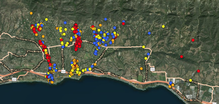 I left out Carpinteria, because of the four structures flagged there, three were blue (affected) and one was yellow (minor), and none were orange (major) or red (destroyed). I’m also guessing they were damaged by flooding rather than debris flow. I also want to make the map as legible as possible, so we can focus on where the debris flows happened, and how we might understand the community’s prospects for the future.
So here are my questions, all subject to revision and correction.
- How much of the damage was due to debris flow alone, and how much to other factors (e.g. rain-caused flooding, broken water pipes)?
- Was concentration of rain the main reason why we saw flows in the canyons above Montecito, but not (or less so) elsewhere?
- Where exactly did the debris flow from? And has the area been surveyed well enough to predict what future debris flows might happen if we get big rains this winter and ones to follow?
- Do we need bigger catch basins for debris, like they have at the base of the San Gabriels, above Los Angeles’ basin?
- How do the slopes above Montecito and Santa Barbara differ from other places (e.g. the San Gabriels) where debris flows (and rock falls) are far more common?
- What geology-advised changes in our infrastructure (especially water and gas) might we make, based on what we’ve learned so far?
- What might we expect (that most of us don’t now) in the form of other catastrophes that show up in the geologic record? For example, earthquakes and tsunamis. See here: “This earthquake was associated with by far the largest seismic sea wave ever reported for one originating in California. Descriptive accounts indicate that it may have reached elevations of 15 feet at Gaviota, 30 to 35 feet at Santa Barbara, and 15 feet or more in Ventura. It may have even shown visible effects in the San Francisco harbor.” There is also this, which links to questions about the former report. (Still, there have been a number of catastrophic earthquakes on or affecting the South Coast, and it has been 93 years since the 1925 quake — and the whole Pacific Coast is subject to tsunamis. Here are some photos of the quake.)
Note that I don’t want to ask Ed to play a finger-pointing role here. Laying blame isn’t his job, unless he’s blaming nature for being itself.
Additional reading:
- Dan McCaslin: Rattlesnake Canyon Fine Now for Day Hiking (Noozhawk) Pull-quote: “Santa Barbara geologist Ed Keller has said that all of Santa Barbara is built on debris flows piled up during the past 60,000 years. Around 1100 A.D., a truly massive debris flow slammed through Rattlesnake Canyon into Mission Canyon, leaving large boulders as far down as the intersection of Alamar Avenue and State Street (go check). There were Chumash villages in the area, and they may have been completely wiped out then. While some saddened Montecitans claim that sudden flash floods and debris flows should have been forecast more accurately, this seems impossible.”
- Those deadly mudslides you’ve read about? Expect worse in the future. (Wall Street Journal) Pull-quote: “Montecito is particularly at risk as the hill slopes above town are oversteepened by faulting and rapid uplift, and much of the town is built on deposits laid down by previous floods. Some debris basins were in place, but they were quickly overtopped by the hundreds of thousands of cubic yards of water and sediment. While high post-fire runoff and erosion rates could be expected, it was not possible to accurately predict the exact location and extreme magnitude of this particular storm and resulting debris flows.”
- Evacuation Areas Map.
- Thomas Fire: Forty Days of Devastation (LA Times) Includes what happened to Montecito. Excellent step-by-step 3D animation.
Leave a Reply