Cranganore (Kodungalur or Kodungalloor) is India’s Edessa. Today it’s a minor port at the mouth of the Periyar River at 10.217°N, 76.217°E, but in antiquity it was the best harbor on the Malabar coast and probably the ancient Muziris. It’s absurdly significant in what might be called the history of the people of the book in South Asia; a major port of trade with Rome, the port where tradition claims St. Thom as landed and where Syrian Christianity is centered, the location of the first mosque in India (the second anywhere, after Medina), supposedly built in 629 during the life of Mohammed, and the landing place too of the first Jews in India, possibly around the time of the destruction of the second temple. It may be that the specific location of Muziris is a few kilometers northeast of Paravur (Paravoor). In antiquity, it was the only entrance to the Kerala backwater; the port of Cochin didn’t exist until the fourteenth century.
(It’s not clear to me if the natural catastrophe of 1314 both wiped out Cranganore and created the port of Cochin, Vypin Harbor, or one or the other. There may be two events, one of which is the flooding of the Periyar River in 1341 [1341, not 1314]. The other might have been an earthquake.)
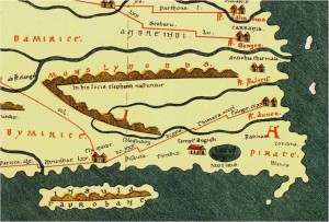
Pictured is the far eastern edge of the Tabula Peutingeriana, what might be roughly described as a Roman map, where you can clearly see Muziris on the southern shore near the island of Taprobane (Sri Lanka) and on the edge of an inland lake — the Kerala backwater, presumably.
