What’s Happened vs. What’s Happening

The fire in Santa Barbara is officially called the Tea Incident, because it started near (or at) a (or the) tea house, on Mountain Road in Montecito. (Here? Ah, no, here.)

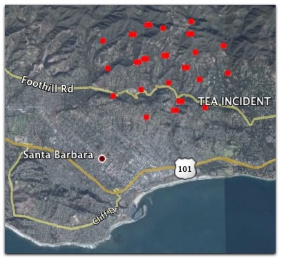
There are lots of good places to see what’s happening. One of the best is this Google Map. KEYT, Edhat, the Independent, Noozhawk and others are helpful. Inciweb has nothing so far, perhaps because the Tea Incident is not yet an official wildfire. It’s usually very helpful once it gets rolling on a fire. And the MODIS maps are great. That’s a screenshot of one, above.

It’s also a little too interesting that temperatures will be as high as 90° today (unusually hot for here) with strong winds from the northeast. Which will be bad, if any of the fire is still going. Some of it will be, but it’s clear that this is not a rolling conflagration like the Oakland fire in 1990 or the San Diego fire last year. Watching the Montecito and Santa Barbara fire chiefs and Santa Barbara Mayor Marty Blum in a press conference right now. The phrases “damage assessment” and “mopping up” are being used. Also “narrow window of opportunity” to contain the fire.

So right now the top thing people want to know is, Which houses have burned down? Can we be exact about what has burned? Saying “over a hundred homes” gives us a quantity of nothing.

If anybody has something exact — streets and neighborhoods, if not addresses — let us know in the comments below. Meanwhile I’ll be headed out shortly to check things out, or at least to sit at a coffee shop and hang out with concerned and/or evacuated neighbors.

[Not much later…] The County Sherrif is on now, and giving specifics. The Mount Calvary Retreat House and Monastery is completely distroyed. (A beautiful place, and a terrible loss.) Areas where many homes burned: Las Canoas, East Mountain Drive, Gibraltar Road, Scofield Park. Mostly inside a triangle between Westmont Collage, the East Riviera and St. Mary’s. (By Rattlesnake Canyon.) Over 100 homes lost, but many also saved.


22 responses to “What’s Happened vs. What’s Happening”

  1. Tea Garden info:

    “Mar Y Cel (Sea & Sky) is a 350 acre estate in the Santa Ynez Mountain foothills above Montecito. The property includes the well known “Tea Gardens” built by Mr. & Mrs. Henry Bothin in the early 1900s. One of Montecito’s most intriguing properties, the site contains the remains of an intricate array of stone aqueducts and water works, Romanesque arches, and Greek-like statues. In September 2000, the environmental investment group Cima del Mundo LLC offered to donate a conservation easement on the northern 150 acres of the estate, eliminating the possibility of residential development and ensuring protection of the scenic beauty and wildlife habitat on this part of the estate. A popular hiking trail, the West Fork of Cold Springs Trail, has run through this area for many years, but it was not on a legally-dedicated easement. Cima del Mundo agreed to grant a one-half mile trail easement to the Land Trust, so that the right to use this trail is now guaranteed to the public.”

    from http://www.sblandtrust.org/openspaces.html

    I’ve been up there and seen the aqueducts – very amazing and cool stuff, though I expect now much of the area is burned.

  2. Lots of damage to westmont college, too, from what I’m hearing. Also sad, but a testimony to their ability to reach students and get them in one place.

    Watching Twitter and your blog for updates, thanks for being so thorough.

  3. At least 14 of the 41 faculty homes on the Westmont campus have been destroyed, along with damage to several classroom type buildings.

  4. […] It’s been all over the news since last night. I was too exhausted to write about it then, but I’ve been following the news all morning on Twitter, FriendFeed and Doc Searls’ blog. […]

  5. Thanks, both of you. Keep it coming.

  6. Governor has declared state of emergency which means more resources will be deployed to fight the fire.

    SB County Sheriff stated that they aren’t seeing any imminent evacuation expansion, they are still very worried about the fire moving into the City of Santa Barbara proper.

    The curious side of me wants to go get some photos but I’m very wary of getting in the way of responders.

    KEYT is showing shots of the planes dropping water on the fire line.

  7. Santa Barbara Bank and Trust is offering to put up people that have lost their homes.

    Details at their main office on Carrillo St.

  8. Hunter, I’m resisting the urge to get up there myself and get photos, because they’ve got enough on their hands. Your updates are terrific, keep them coming, please.

  9. Direct Relief says in a press-release that, “Free masks will be distributed to area residents in the parking lot off Las Positas, near the intersection with State Street. The N-95 masks help protect against inhaling particulate matter in smoke and ash, a particular concern for people with respiratory conditions such as asthma.”

  10. Daryl Cagle and his son evacuated last night. Haven’t been able to find any update as to whether his house was spared He has a blog entry here: http://cagle.com/news/BLOG/main.asp

    Daryl is an awesome political cartoonist. I hope for the best.

  11. I heard an hour or two ago that the upper end of Hyde road off Mtn Drive has been completely consumed. This via a photographer who is up there doing ostensible journalism — we had friends there and he confirmed their place is burnt to the ground.

  12. Oh, by the way, how do you get to the more detailed MODIS images? I’ve been fooling with their site for a while and can’t reach anything that shows the fire as more than a single red blob.

  13. I hear the roads are clogged with people trying to take pictures of the fires.

  14. ‘The Arches’ in the ‘Tea Garden’, for which this fire is named:

    http://www.sbphototours.com/data/static/georgelogan/marycel.php

    This is right above Westmont College off of Mountain Drive.

  15. Kathleen McCain Engman Avatar
    Kathleen McCain Engman

    I’m in Pennsylvania. I read about this blaze on my hometown [Culver City] parish’s e-update [St. Mary Palms], reporting that our retired Rector was evacuated along with all other residents from the Mount Calvary Retreat House up at the end of Gibraltar Rd behind Palmer Park. Can you confirm that the Monastery and grounds have been lost? I am so sad and anxious for everyone up in this beautiful, fragile, and dangerous landscape. Our prayers are with you all. [Your website is the only place I have been able to find accurate, timely reporting.] Thank you.

  16. Kathleen McCain Engman Avatar
    Kathleen McCain Engman

    Sorry — clicking too many links, back and forth, simultaneously. Sadly, I see you have confirmed the Monastery’s loss. KME.

  17. Doc, I’m so sorry to hear about the fire. Stay safe. Sending you waves of compassion from Santa Cruz.

  18. Crisiswire is aggregating twitter stream, ustream feeds, and news feeds on one page http://crisiswire.com/2008/11/santa-barbara-fires

  19. Just set-up new local Santa Barbara Bulletin Boards available for fire and other local discussion:

    http://tinyurl.com/5c7wn4

    Also local citizen news feed aggregation:
    http://sb.city2.org/feeds/category/11

    And growing comprehensive local news aggregation:
    http://sb.city2.org/feeds/category/all

  20. bmh, the MODIS images I get by going to this page and clicking on “Fire Detections: Current” in the KML column. This will download a file (with the suffix .kml) which, when opened, will add a layer to Google Earth that shows where fire detection spots are. It’s complicated, and works differently on different platforms. Hope that helps.

    Everbody else, thanks for the details. Very helpful.

Leave a Reply

Your email address will not be published. Required fields are marked *