Jesusita Fire Watch

jesusita_google_modis

We’re in Boston, watching neighborhoods near our own in Santa Barbara, burning as the Jesusita Fire spreads south out of the mountains and into town. KSBY is running a live feed from a helicopter here. The audio is on constantly, so you can hear the pilot talking with the studio when reporters aren’t.

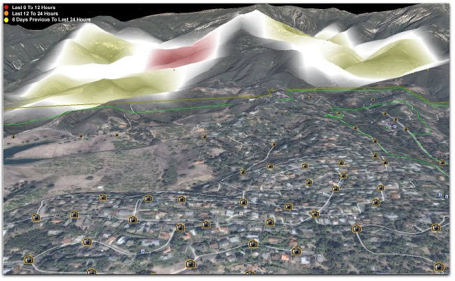
Here are some screen captures and Google Earth views, enhanced by MODIS satellite overlays. MODIS detects heat on the ground from a satellite that passes overhead a few times per day. One of those is above. The MODIS information is from early this afternoon. No new ones have been posted since then, and it’s now 7:50pm. The fire has spread into the middle left part of the shot above. If you go here and mouse over the picture, you’ll see the area that has been burning. The fires are in patches.

Here’s a google map with lots of helpful info.

KCLU radio is running constant coverage. Listen here. Good that they fired up a good new signal on 1340am. Lots of listeners calling in right now. [Later… KTYD is now running nonstop coverage.]

Much of the town is under evacuation orders, including areas that run all the way down to State Street, which is the main drag through the middle of town. Our home is in one of the mandatory evacuation zones. We’re highly evacuated, yet wishing we were there.

The winds are clearly from the west, moving straight east, toward Mission Canyon. In the path is the Cheltenham Road area, which is hill covered with lots of foliage and lots of houses. This is an area very much like the Oakland Hills, where I watched more than 3000 homes burn in 1991.

The last house that burned on TV is west of San Roque Road and Lauro Canyon Reservoir (which appears in some of the footage). I think it’s on Santa Terasita Road, off North Ontare. I’m taking some screen shots and trying to match them with the terrain view on Google Earth. I’ll put those shots up too.

One structure I see burning appears to be on the north side of E. Alamar Avenue, behind the Cheltenham neighborhood. Not sure, though.

I’d say this is surreal, but it’s all too real, and familiar. And scary as shit.

Okay, flames on San Roque Road, above the reservoir. Spyglass Ridge Road. Maybe Palomino Road. It would be nice if the reporter or the pilot would identify the roads they’re looking at. Instead they’re talking about hitting the Elephant Bar after they land.

I also notice that the winds have stopped. There appears to be a lull. The smoke is moving in the vertical direction. This is very good. Hope it lasts.

8:13pm Pacific. Here’s a Twitter stream on the fire. Props to KCSB for that one.


14 responses to “Jesusita Fire Watch”

  1. David Spargur Avatar
    David Spargur

    OK Marty Spargur is on the golf course above Loreto plaza and he said our house hasn’t burned. He said it the fire went across to the west on the ridge near botanic gardens I think and bypassed the ridge our Cheltenham house is on. He thinks it burned a house on Montrose.
    He said the fire seems to be climbing up to Camino Cielo which I guess is good, the wind must have switched to onshore.
    – David 7:53 pm Wed

  2. I lived and grew up, partly, for most of my life. I now live in Santa Ynez. Driving back from Santa Clarita on Tuesday. I switched on KTYD and caught the end of a message about fire. As soon as I rounded Mussel Shoals I saw the smoke plume. Really a somewhat small column of smoke. As I started up the San Marcos Pass Road, right around the 192 exit, I could see a big ‘patch’ on my side of a ridge with huge flames. Wind in DT SB was calm but, just past san antonio creek I was getting buffeted around and my car is low profile. Of course, after I got home and got the news on it had grown from 5 acres to 100 acres. I rebuilt many destroyed homes after the Sycamore fire. One for a dear family friend on Las Alturas. It went down again in the TEA fire. Very Sad.
    ~ Doc Searls, thanks for the best page/site/blog that I have seen regarding this. Are you the Doc that has the helipad that the choppers are using??
    ~ My DDS lives on Santa Terresita. Hoping he is OK. From I can tell from all the data and video that I have seen, there have been a LOT of homes burned. Whey we can’t get some actual streets and more accurate info from the media is frustrating. KEYT and John Palmintery have been doing ok. They are just now starting to ask more questions as to location. It is spotty as was the case with the Coyote fire and the Sycamore fire. Currently it is burning UP the hill above Santa Jesusita Lane. JB in SY

  3. Edhat (http://www.edhat.com/site/tidbit.cfm?nid=19490&linkSource=edhat.com) also indicates houses on Cheltenham OK, but lots of burned houses nearby. The KCOY copter reporter was much better on reporting addresses, noted burned houses along Holly Rd.
    That area W. of Tunnel Rd was hard hit.

    I’m sitting here in Virginia hoping I’ll know tomorrow whether my stepmother’s and late father’s house on the east side of Mission Canyon is still there.

  4. I hope your home makes it thru. For once I feel lucky that we are in Santa Maria right now.

  5. michelle kendall Avatar
    michelle kendall

    As a SB native / lifelong resident who happens to be in Australia with my husband (on sabbatical from UCSB) this year, it has been so torturous to not have access to very accurate info for two big fires that threatened our family home. Thank you for your efforts trying to pinpoint the active burn areas. Great GIS wizardry.

    I will be back for updates.

  6. Thank you for the info. I’m in Minnesota looking at the map and watching. Our home is in Montecito. I’m leaving this am to go back. I hope your homes make it OK.

  7. These fires happen every year. One would think that the state would invest in a response force sufficient to stop them in their tracks, rather than putting people through the same ongoing saga each time.

    In Winnipeg, they just had record-level floods. Again. But the city was spared any significant damage because it invested something like 600 million in a floodway and water diversion plan. If a little Canadian city can do this, California can.

  8. David (Spargur), it was pretty clear by the KSBY video that the whole Cheltenham Hill was fine. That is, until the KSBY guys went to re-fuel and hit the Elephant Bar. We didn’t see any more from them. Hope your folks are doing fine wherever they’re evacuated to. If we were there, we’d be seeing them at mass on Sunday. Right now that (along with the Mission) is in the evacuation area too.

    David (Sewell), from what I could tell, the east side of Mission Canyon is still okay, or was last night. With the winds slacking overnight (which citizen reports said they had), that area might be easier to defend by morning. Hard to say, though. The whole place is so vulnerable.

    Stephen, fires happen every year, but on average in Santa Barbara itself once every seven years. Nothing came close between the Painted Cave fire in 1990 and the Gap Fire early last year. That fire was well-fought and only one structure (not a house) was lost, as I recall. The Tea Fire last November was the first fire to burn homes in 28 years. The use of new firefighting methods and equipment spared many more homes, including ours. Coordination between all the administrative parties involved — city, county, state, federal, land management bureaus, state parks & recreation, state and national forests — is much better coordinated than ever before.

    There is no way to stop a California wildfire “in its tracks”. The fuel is often so dense, and the flames and smoke so wild and thick, that there is nothing that can be done. Fires also spread mostly by burning debris that can fall up to several miles away. The homes burned in the Jesusita fire were, I can tell by the pictures, victims of spreading “hot spots” ignited by debris.

    The new firefighting helicopters are capable of shooting water directly at hot spots. And they are helped at night by night vision goggles. But in high winds — some over 70 miles per hour in the Tea Fire — these helicopters can’t fly. In mountainous areas it is also hard for planes to lay down fire retardant.

    The awful fact that we refuse to face (our family included) is that much of California was meant to burn over every few years. It’s also meant to shake. The state tree, the redwood, grows as tall as it does, with branches that start 200 feet up, and thick slow-burning bark, because it is adapted to fire. The state flower, the California Poppy “grows well in disturbed areas and often recolonizes after fires.” Read “disturbed areas” as earthquake country. Think about it. (We certainly do.)

    As for the Winnipeg comparison, it’s far more relevant to the Mississippi flood-prone areas, where there has been plenty of infrastructure neglect. The resemblance between fires in wooded mountains and floods in prairies is approximately zero.

  9. Doc,

    As you so rightly note, the fact that redwoods are adapted to wildfire doesn’t make it any easier to watch a fire creep ever closer to your home.

    Now that I live in Sweden, it has become easier for me to wonder why people in California insist on facing so many natural dangers (wildfire, floods, mudslides, earthquakes, drought) year after year.

    Then again, I’m a native Californian. And when I was still in the Bay Area, my only question was how anyone could bear to live anywhere else. Someday I will return and will probably feel exactly the same way again. At least my block had earthquake drills. 🙂

  10. Barry Winick Avatar
    Barry Winick

    Doc, I knew I could count on you to post some informative pics. It is almost 6AM and the winds are still blowing here on the Riviera. It seems as though they are blowing up from the ocean towards the hills. The air traffic has been non stop. Got to give a lot a credit to the copter hot doggers. Best to you

  11. It’s been 14 years since I left my long-time home on Cheltenham for Chicago, but Santa Barbara will never leave my heart.

    The phrase “stay cool” was never more earnestly uttered. Good luck.

  12. Willard Hastings Avatar
    Willard Hastings

    stillVery well done commentary on the Jesusita fire, Doc. This is our fourth day of obligatory evacuation listening to the many radio commentators describe the scene with repitition. Your observations carried out from 3,000 miles away are quite remarkable.

    People are getting away from town this weekend as witnessed by the miles long bumper to bumper traffic on Highway 101. We sent an undercover agent to sneak through the police blockade and were informed our house was still standing. Hoping to luck out in a few days.

    Will
    Santa Barbara

  13. How is Cocopah Avenue? I have friends there.

  14. Vigilante, Ray Ford says here that Cocopah is fine.

Leave a Reply

Your email address will not be published. Required fields are marked *