
(Scroll to the bottom for my latest. Not the latest, just mine.)
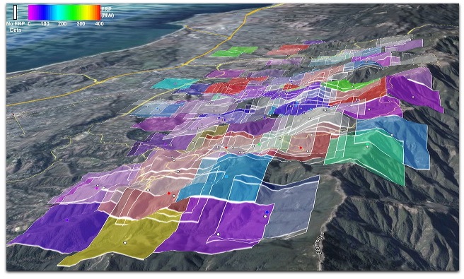
The shot above looks west from the eastern flank of the Jesusita fire, above Montecito. The overlays are MODIS (the dots and squares) and GEOMAC (the red line). I think the GEOMAC data is older, but I’m not sure. Both were downloaded at about 4:42am, Pacific time. The newest detections are red and the oldest are yellow. They are from instruments on satellites and may or may not indicate major fire activity. One during the Tea Fire suggested that the fire had spread far down into the Riviera district and toward town. When I checked the spot, it turned out to have been a fire in part of a small isolated oak tree. No fire had spread to or from there.
Still, the data do show changes in the fire’s approximate perimeter over time. Step through this photoset and you can see how the fire has gone over the past few days.
Sean Trek has a way of seeing MODIS with radiative power.
It looks to me now like the next challenge, after saving lives and homes, is keeping the fire from burning for many more days or weeks across the back country. The trick here is to let the fire take nature’s course while also keeping it away from civilization. It is a significant fact that California’s state tree (the Coast Redwood) and state flower (the California Poppy) are both adapted to fire. One might also make the case that the latter is adapted to earthquakes.
I don’t doubt that if any of the three most recent fires — Gap, Tea and Jesusita — had hit fifty years ago, much of Santa Barbara would have been cremated by this morning. Since we are among more than 30,000 current evacuees, that might have included our house too. Firefighting and team coordination have vastly improved just since the 1990 Painted Cave Fire, when more than 600 homes were lost. Experience from that fire led to many of the improvements that saved homes this past week. (For a history of Santa Barbara’s wildfires, go to Santa Barbara Outdoors, and read the remarkable series that starts here. It covers the eight fires between 1955 and 1990.)
Life everywhere is a losing game with death. We just hope that the substantive things we do and build will outlive us. In much of California, the chance that our homes will outlive us is smaller than most other places. Some homes lost in the Tea Fire had replaced homes on the same property that had burned in 1964 Coyote Fire and again in the 1977 Sycamore Fire. Among disasters that might befall homes in California, only earthquakes are more certain to occur, and in more places. Hence the higher insurance costs.
But still the graces of living here are exceptionally high. Mild, sunny weather. Clean air. Beautiful mountains and beaches. Wonderful people. Excellent university. So we do.
And every day we should thank the heroic work required of the firefighters who keep the worst of nature at bay. Posted 5:38am, Pacfic.
Meanwhile, I’m glad to see the subtitle in Gretchen Miller’s report in the Independent, Fires Burn In Canyon Near Painted Cave: Favorable Weather Conditions Keep Fire Under Control. From around 10pm last night. 6:20am
The LA Times has a story on the fire, dated 10:28pm last night.
Last night on KCLU before going to sleep I heard that the Gane House at the Santa Barbara Botanical Garden was destroyed. This confirms it. 6:28am
A news conference is scheduled for 8am. Just heard that on KNX, which has done an excellent job covering the fire.
Okay, the press conference just ended. KCLU, KNX and KTYD (and, presumably, some or all of its four sister stations) all carried it. KCLU bailed before it was over. So did KNX, though they stuck it out a bit longer. Only KTYD stayed until the end. (Bravo for them.)
The news that matters is that the fire is “contained” along the northern border of Santa Barbara. Thus spake SB Fire Chief Andrew DeMizio (who always starts by spelling his name). He was glad to see “that black line” on the new Incident map. Contained does not mean put out. He had another word for that, but I forget what it was.
The language is interesting. A fire is an “indicent”. Police, fire, Red Cross and other personnel are “assets”. Lifting an evacuation order is “repopulation”. My kid just said, “I thought ‘repopulation’ was what you got after the first population has died”.
Inexcusable, if true: No questions about locations still apparently threatened. (Could be that somebody asked and I didn’t hear it.) Specifically, the only two communities up in the Santa Ynez Mountains, overlooking the city: Painted Cave and Flores Flat. I gathered from the Indy story mentioned above that Painted Cave was okay. But the only way I knew that Flores Flat survived was from a little human interest feature that KNX has been running over and over again: comments by a woman who gave advice about what to take and what to leave behind. She said she had resigned herself to losing her home in Flores Flat, but was surprised to find it had survived. Frankly, I’m amazed that Flores Flat is okay. I’ll bet the firefighters gave special attention to that one. Maybe one of the places where the DC-10 laid down some of its 12000+ gallons of fire retardant was between Flores Flat and the fire.
Flores Flat is far up Gibraltar Road, between Gibraltar Peak (where many of Santa Barbara’s FM stations radiate from, including KCLU and KTYD) and the site farther up the mountain face where hang gliders and paragliders launch toward the city when the winds are right. From the looks of the map and overlays above, the fire movement was eastward away from Gibraltar, and up and over the crest of the ridge near Montecito Peak to the east and LaCumbre Peak to the west.
The Tea Fire surely created a fire break as well. It burned much of Gibraltar road, and up the face of Gibraltar Peak, where it roasted the antennas of KCLU and many of the other stations there. KTYD and its AM sister KTMS are located a few hundred feet above and behind there, so they survived. To the west of there are some of the main power lines that supply the city. As I recall those lines are draped quite high, and I suppose survived the fire as it approached Gibraltar road this time. Other high power lines coming into the Goleta side of town were hurt in the Gap Fire last summer, knocking out power for much of the city at the time.
The weather is much better now. Cooler, and moist, with marine layer fog moving in off the Pacific Ocean to the south. Vari0us officials cautioned that this could change, and in fact it probably will. Typical late Spring and Summer weather is early morning fog, burning off as the day goes on. Whether hot “sundowner” winds return is still an open question, but various weather sources suggest that won’t happen. On the other hand, if the fire gets into Paradise Valley on the north side of the ridge, the story might be different. The climate there tends to be much hotter and dryer than on the Santa Barbara side of the mountains. 8:50am
We have friends in Worchester who were going to Santa Barbara to see Katy Perry’s last show, in her home town. That last link is from Noozhawk, which I’ve neglected to follow more closely. The reason is that Santa Barbara is being repopulated with a raft of new and improved media sources growing like a ring of redwood sprouts where a mighty tree has fallen. That tree is the Santa Barbara News-Press, a once fine newspaper that was (and remains) in a much better position to survive than papers in other cities that are owned by stressed public companies or private individuals with shallower pockets. The story of the News-Press’s meltdown is not yet the stuff of legend, only because it’s still going on. Kind of like a fallen tree with a few intact roots, staying alive, but barely. For more on that, just look up Wendy McCaw on Google. Or read Craig Smith. It’s his main beat. A sample:
A major fire in town didn’t stop the Santa Barbara News-Press from doing business as usual. In this case, “business as usual,” meant laying people off.
This time, the unlucky employee was Jued Martinez. He was a digital image technician for the paper, the “go-to-guy for Photoshop issues,” as he put it, working in the camera (pre-press) department for many 15 years.
He announced his own layoff via Twitter around 1:40 Thursday afternoon by saying, “Wow! I’m available for Design work now. Just got laid off from the SBNP. Feel a little better now, not worrying about it.”
To witness how retro and self-destructive the News-Press is, go to their Jesusita Fire Coverage page. Click on a story. Say, this one. You get one sentence. Then you’re told to long in. Subscribers only. Hell, even when we were subscribers, we couldn’t get in there. I’m sure it all disappears or scrolls behind a paywall after a few days in any case. Gone like snow on the water.
Except as a source of fodder about itself, the News-Press plays a self-minimized role in the local news ecology. For getting news on the fire, that includes:
- Twitter search for Jesustiafire or Jesusita (@latimesfires uses this search)
- Google News search for Jesusita (most recent)
- The Independent
- Edhat
- Noozhawk
- City2
- KNX
- KTYD
- KCLU
- KCSB
With the radio stations, I mean their streams, not their sites.
I’ll add others later (including stream addresses). Gotta go. Here’s a photo pool in the meantime. 9:33am
And here’s one last photo, courtesy of the only commenter so far on this post:
Thanks, nathan. 10:19am
They’re “repopulating” at last. The worst is over. 10:48am
Leave a Reply