A few days ago RadioInk reported that WTOP, the all-news radio station in Washington, D.C., is now the top-billing station in the nation. Two surprising things there. One is that Washington is the #7 market (behind New York, Los Angeles, Chicago, San Francisco, Dallas-Fort Worth and Houston-Galveston), and that in the latest ratings WTOP is #2 overall, behind WAMU, the top local public station. (WAMU gets an 8.2% AQH, or Average Quarter Hour share, to WTOP’s 6.9%,)
One non-surprise is new competition, from WNEW — “all-news 99-1,” created by CBS, which owns the top news stations in New York (WCBS and WINS), Chicago (WBBM), Los Angeles (KNX and KFWB), San Francisco (KCBS) and elsewhere. Of the ten top billing stations (according to that same RadioINK story), five are all-news, and all but WTOP are owned by CBS. So clearly CBS would like to compete in a town that makes more news than any other.
So far, however, WNEW has been all but nowhere in the ratings. WTOP has slipped a bit (a month earlier it was #1 with a 7.5% AQH share), but WNEW went from 0.3% to a “-“. Not good. Still, according to this piece by Ben Fischer in the Washington Business Journal, CBS says things are going “according to plan.”
 As an old radio guy with a transmitter obsession that I’ll never fully repress, I’m wondering if the signal is an issue. WNEW, which is licensed to Annapolis, transmits from a tower in the woods near near Patuxent River Park, between Bowie and Crofton, in Maryland, about four miles east of the 197 exit off the Baltimore-Washington Expressway (295). The maxium power allowed for FM stations in the Northeast is 50,000 watts at 500 feet (above average terrain), and WNEW puts out the equivalent of that with 45,000 watts at 515 feet. (Coverage results from a combination of power and height. You need less power at higher antenna heights to achieve the same coverage. Most FM stations in New York radiate from atop the Empire State Building with 6,000 wats at 1361 feet.)
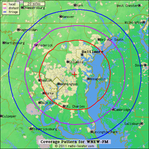
Could be the idea is to cover both Washington and Baltimore, which it does, as you can see from the Radio-Locator.com map on the right. The red line is the calculated extent of strong signal coverage. But signal strength still falls off with distance from the transmitter, and it helps to be in the middle of town, as WTOP is.
Recently I drove around both cities, and WNEW sounded fine there in a car. Homes and offices are another matter, though. Car radios tend to be pretty good. Home radios and portables much less so. On a kitchen radio in Baltimore, about the same distance from WNEW as, say, Arlington, Virginia, WNEW was all but inaudible.
Some history.
WTOP began life at 1500 on the AM dial, with a powerful directional signal pumped out by its three-tower 50,000-watt facility in Wheaton, Maryland. The signal on the ground covered most of the metro area by day, though it left out places to the west, especially at night. (Thanks to the reflective qualities of the ionosphere at night, the station could also be heard well from North Carolina to the Maritimes.) The Washington Post, the primary owner of the station back then, made WTOP all-news in the mid-1960s. (Around that same time, the Post also made a royally dumb decision to donate its FM station, on 96.3fm, to Howard University, where it thrives today as WHUR — because the Post didn’t believe people were going to listen much to FM.) Then, to make a long story short, the station went through a series of ownership changes and facilities proliferations until it arrived at this current state (first links go to coverage maps):
- WTOP, the namesake, radiates on 103.5fm, with 44,000 watts at 518 feet above average terrain, from the American University tower it shares with WAMU, WKYS, WMMJ and WPFW. This is equivalent to the legal maximum of 50,00o watts at 500 feet; except that the station has a directional signal, with a dent to about half that power in the Baltimore direction.
- WTLP, on 103.9, with 350 watts at 950 feet above average terrain, on a ridge alongside Gambrill Park Road, overlooking Frederick, Maryland.
- WWWT, on 107.7, with 29,000 watts at 646 feet, also equivalent to the legal max of 50,000 watts at 500 feet. on a hill overlooking Warrenton, Virginia.
- W282BA, on 104.3, a 100-watt translator on a tower in downtown Leesburg, VA.
- All four simulcast and identify as WTOP.
Meanwhile the old signal on 1500 is now WFED, called FederalNewsRadio. It is simulcast on WWFD on 820am in Frederick, MD. That transmitter is a two-tower rig, alongside I-70 just west of Frederick. It’s 4,300 watts by day and 430 watts at night, when its signal is aimed east over Frederick. Both WTOP and WFED are owned by Hubbard Broadcasting, which recently bought them from Bonneville.
Maybe CBS will buy up a fleet of secondary stations around the edge of the market(s), like WTOP did. That might help. Meanwhile, I think that signal is a problem.
I could say more, but I’d rather just put this up. It’s been languishing in my pile of drafts for long enough, waiting for me to say more. Rather than that, I’ll just leave the rest of that up to those of you who care.
Leave a Reply