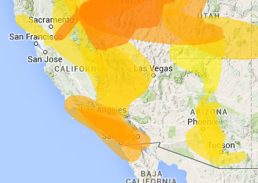
Right now every FM and TV station in Santa Barbara and San Diego can be heard in both places. Between them lays more than 200 miles of ocean across a curved earth. I’m not there right now, but I see what’s happening remotely over my TV set top box. (Thank you, SlingBox.) But, more importantly, John Harder‘s tropo map tells me so:
Tropo is tropospheric refraction of radio waves across a distance. Atmosphere has refractive properties that don’t matter most of the time. But we can see changes, for example, with mirages ahead of us above a hot road, which causes the air above to refract light at a low angle, essentially reflecting the sky, other cars and landscapes on the horizon. Something like this also happens over land and water for FM and many TV signals.
I see by the map above that tropo is happening in other parts of California, Nevada, Utah and Arizona. I also see that it’s starting to happen here in north central North Carolina, where I can already pick up stations in South Carolina:

On 88.1fm, for example, I’m getting WRJA from Sumter, South Carolina, atop WKNC in Raleigh. WRJA is about 160 miles away while WKNC is only 40 miles away. But WRJA is 100,000 watts atop a thousand-foot tower, while WKNC is 25,000 watts on a 260 foot tower. (It’s actually as little as 35% of full power in most directions from the transmitter at NC State. They have a construction permit to change that a bit.) So they’re making a hash of each other here.
Back when I lived in the woods north of Chapel Hill, long before the Internet showed up and made all of this stuff irrelevant for listeners (who can get the same stations on the Net, anywhere), I had a directional Finco FM-5 antenna and a Channel Master Crossfire 3610 antenna (both salvaged from abandoned structures) on a pole next to my 1-story house. I rotated them by hand. If I had the same rig here I could point at either WRJA or WKNC and “null out” the other. I did this on hot summer mornings for fun back then, and eventually logged nearly every FM station from Pennsylvania to Georgia. (It’s a summer thing, and coincidental with heat waves over large areas.)
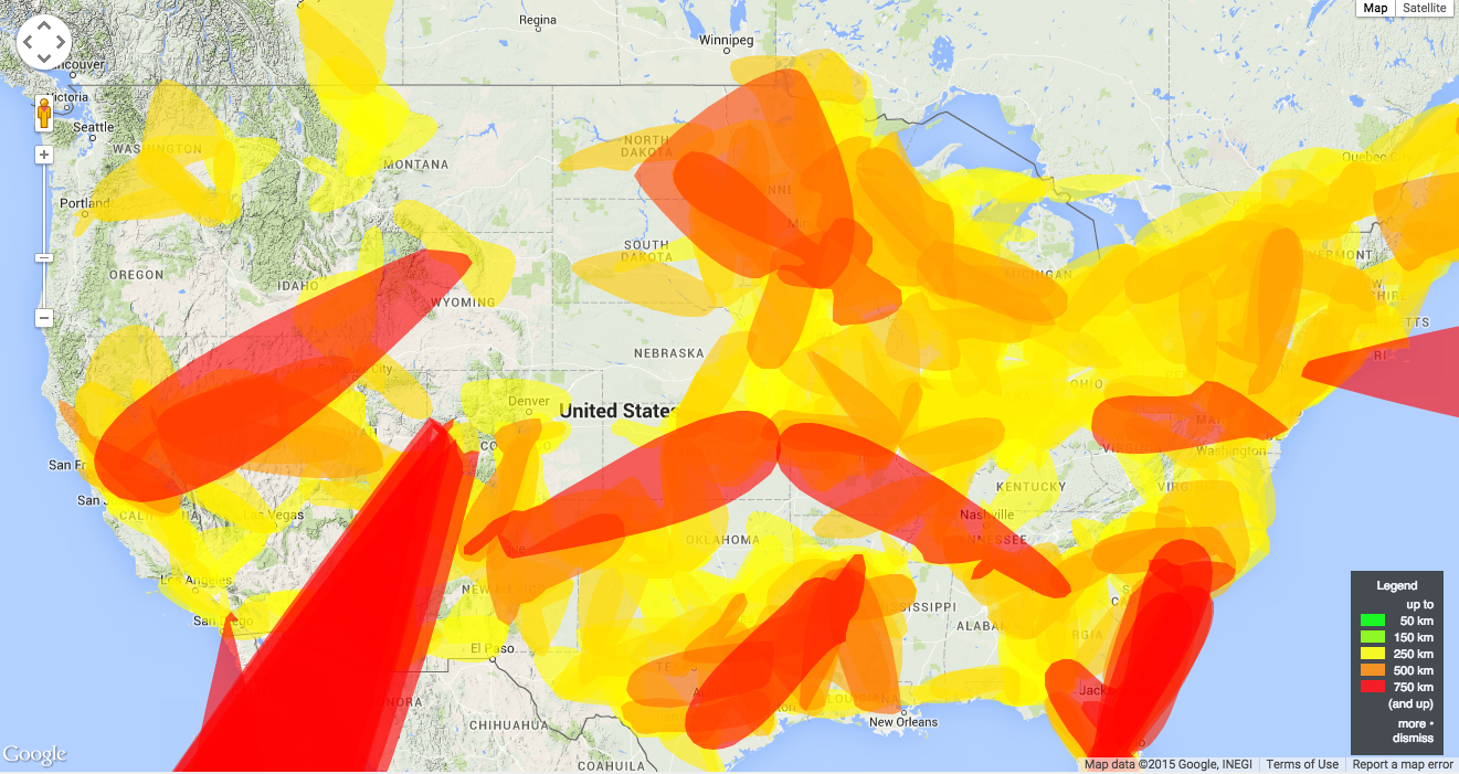
Here is a whole-country map that shows tropo happening pretty much everywhere:
I would love to have had this kind of resource back in those days. Now that I do, it’s hardly worth the trouble, since nearly all my radio listening is over the Net.
Anyway, if you’re wondering why your local station is being obliterated by a signal coming from a state or two away, or why you’re suddenly getting far-away stations where none were before, tropo is the most likely reason.
The second most likely one is Sporadic E skip, which brings in stations from distances of 800-1200 miles or so away. In that case the E layer of the ionosphere turns into something like a hot road surface, reflecting distant signals, but only at a certain angle. I’ll cover those in a later post when the phenomenon is actually happening. It’s not right now.
Meanwhile, if any of this intrigues you at all, check out William Hepburn’s amazing Worldwide Tropo Forecast Maps. Great eye and brain candy, because it exposes a real-world view of the world that isn’t what you see with your eyes.
Leave a Reply